Saturday, Sept. 30
5:00 pm
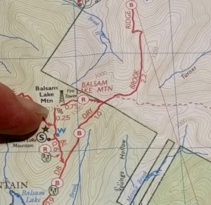 Explore the world of topographic maps.
They tell us a lot about the land around us.
A ‘topo’ map shows the shape of the Earth’s surface with contour lines. These lines make it possible to measure the height of mountains and steepness of slopes – great information for anyone planning a hike or a fishing outing.
BRING a favorite trail or fishing map with topo features to share, show others a particular map feature you like – or just come!
This will be a relaxed gathering for map enthusiasts; beginners are welcome. Light refreshments.
RSVP at 845 439 5507.
Co-Sponsored by the Catskill Fly Fishing Center & Museum, to compliment the “Catskill Rivers and Trails” exhibit
at Morgan Outdoors through Oct. 9th.
Map: from of the “Catskill Trails – set of 6 maps” published by the NY-NJ Trail Conference (and sold at Morgan Outdoors).



Recent Comments